Thursday, February 16, 2012

Urban Air & Climate

Last week in class, Dr. Jeremy Diem came to our class to give a presentation on air pollution and its effect on climate change. He explained how particulate matter concentrations are attributed to higher temperatures which propagate already worsening urban air pollution levels, and it also creates changes in rainfall patterns. Here are some of the things we learned from a reading of his study:
1) There are 11 ozone monitoring stations in the Atlanta Metropolitan Statistical Area.
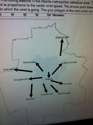
the locations of the monitoring stations
2) An HOD is a high-ozone-day and they are most common from June to August, the warmest season in Georgia. 
3) The southeastern part of Atlanta (McDonough, Conyers, Panthersville stations) generally observe the highest ozone levels, and the northerly-located stations of Yorkville and Dawsonville had the lowest levels.
4) HODs occur with hot, dry and calm weather.
5) HODs are associated with nitrogen oxide emissions from electric power plants.
6) HODs are perpetuated by above-average mixing heights above ground level (in the air) which causes it to spread over a larger area of the atmosphere above the Atlanta MSA.
HODs and wind direction
7) Because air circulates clockwise around anticyclones (large descending parcels of air with high pressure), the diagram below shows that pollution from Power Plant B would blow pollution in a southern direction, and pollution would blow from Power Plant A in a northwestern direction. Thus, it makes sense that pollution levels are high to the southeast of Atlanta because of the large power plant to the northwest of the city.

Some of the other things we learned from the presentation, about...

- Particulates
    1) Small particulate concentrations in urban areas are caused by fossil fuel burning, mostly by automobiles.
    2) On-road emissions and power plants also attribute to particulates in the air.
    3) Places with high particulate optical depth include: the Sahara Desert due to dust, the Amazon rainforest from August to October due to biomass burning of forests, China and its coal-burning particulates, and the eastern half of the United States during the late summer months. (see photo below)
part of an animation showing change over time
- O-Zone
    1) The lowest levels during the day are recording in the early morning, around 7:00am.
    2) Towns to the south of Atlanta have the highest o-zone levels because they are downwind of Ohio River Valley winds.
    3) It is created by nitrous oxide emissions and volatile organic compounds, together with ultraviolet radiation, as shown in the photo below:
the "recipe" for o-zone
- Acid Rain
    1) It kills plant life, pollutes rivers and streams, and erodes stonework.
    2) Pure water has a pH of about 7, while acid rain is exponentially more acidic with a pH of about 4.
    3) There has been a shift in rainfall in the Atlanta area since the Clean Air Act of the mid-1970's due to small particulate matter clouds (NOx and SO2), with rainfall suppression before it and an increase after it. Observe the change below:
average rainfall in Atlanta

- CO2
    1) Fossil fuel emissions in the Atlanta MSA are approximately 4800 metric tons per square kilometer, which is 8 times more intense than the national average.
    2) Most concentrations of carbon dioxide in counties around the city of Atlanta are largely due to automobile emissions.
    3) There is a carbon dioxide monitoring station on the top of a GSU building which is constantly observing levels in the air in downtown Atlanta. You can see its results here:


Thursday, February 9, 2012

Sustainability and the Southface tour

Our class last week consisted of a tour of the Southface building, which is located near the Atlanta Civic Center. It was opened slightly over thirty years ago to promote green efficiency as well as quality construction for residential buildings. We learned that in the next forty years 2/3 of all growth in the United States will be in the South, therefore there is an urgent need for sustainable building in future construction projects. Here are some photos of the interesting things that have been used to build Southface:
windows facing south for maximum sunlight exposure
artificial stream for storm water runoff
paneled carpeting for easy replacement

window shields to distribute sunlight across rooms
automatic faucets with light-rechargeable batteries
display panel depicting up-to-date energy use
the machine room, which houses the compost toilet
minimal-water use toilets that feed into compost processor
green roof with German Sedums (stone-crop)
I think the most interesting thing about the Southface tour was that the aspects of sustainable energy found in the building were actually functioning! A common issue that people have with such technologies is that they do not work well, or work at all sometimes. This building is a wonderful example for people to observe quality construction and function in a manner that is easy to maintain, and is worth while. I highly recommend a visit if you are in the Atlanta area. It is located near the corner of Piedmont Avenue and Pine Street.
( http://www.southface.org/ )

Information about Sustainable Building 
from our text, Cities & Nature: (pg.238-240) 
1) The basic difference between the 20th century view of housing and the view of the sustainability perspective is that planners previously "tended to view housing within a vast infrastructure grid of gas, electrical power, water supply and sewerage." These grids became quite extensive with urban sprawl and suburban growth. More recently, sustainable housing planners "would localize the impacts of growth by insisting that as many resources as possible (water, energy and food) are source, processed and disposed of locally" (238).
2) In a house, the three main systems that contribute to sustainability are:
  - the waste system
    (example: a biolytic filter intakes sewage, good waste and other organic material into a multi-layered filter bed concrete tank with worms and micro-organisms. they sift, sort, digest and treat the solid waste and waste water from showers, baths, toilets, sinks, and dishwashers. it is then pumped into a UV-tank to further clean the water, which can then be used to water a garden.)
  - the drinking water system
    (example: rooftop rainwater collection tanks can collect and filter rain to be used for watering gardens and as drinking water)
  - the solar energy system \
    (example: photovoltaic cell solar panels)
3) Building materials are also an important part of sustainable building. The use of re-growth timber or materials produced by pollution-free manufacturing and free of toxic chemical discharges is necessary. (example: thick straw bales as wall insulation) Many use stoves which burn wood pellets or corn kernels instead of natural gas furnaces. Also, concrete flooring keeps a house cooler in summers and warmer in winters.
4) A very important concern for building sustainably is to maximize the use of the Sun during winter months to provide light and warmth by having the main windows of the house facing south, in the northern hemisphere.
5) Some suggestions for building materials in green buildings are as follows:
  - non-formaldehyde and/or non-toxic properties (improves indoor air quality)
  - high renewability or reusability (bamboo flooring, cork titles, etc.)
6) The advantages of green roofs include:
  - soaking up rain water instead of funneling runoff into sewers
  - reducing energy costs (summer AC needs, winter heating)
  - lowering carbon dioxide levels
  - providing bird habitats
  - removing nitrogen and other pollutants from rainfall
  - diminishing the 'Urban Heat Island' effect

Friday, February 3, 2012

Urban Ecosystems and observing landscapes

The lecture last week, lead by Dr.Edwards, was on the topic of what a natural ecosystem is and how an urban ecosystem is similar and/or different. Here are some of the interesting things I learned from it:
- The functions of urban ecosystems are to:
  a) improve quality of life
  b) improve environmental conditions (mediates climate, increases carbon storage)
  c) contribute to native plant and animal diversity & population strength
  d) reduce negative human impact on watersheds 
- Factors that control temperature of an ecosystem as well as a specific location are:
  a) slope position and steepness
  b) how shaded the site is
  c) aspect (the compass direction in which the site faces)
- There have been studies that have observed and recorded clear adaptations by plant and animal species to living in urban environments, such as various bird types chirping at higher pitches to compensate for the great amount of noise found in a city

Our class activity for the day was to walk around three urban greenspaces on our near the Georgia State University and observe characteristics such as soils, microclimate, moisture retention, geology, exposure to trampling, plant and animal life, community, and contribution to the functions of urban ecosystems. We found that all three of the greenspaces exhibited clear signs of definitive planning with a focus on aesthetic appeal and not a lot on recreating the natural environment. Here are the places we explored:

outside of the Student Center (Gilmer Street & Courtland Ave)
campus courtyard a.k.a. "The Quad"

Hurt Park
After class ended, I had the wonderful opportunity to go away for the weekend. I went to Florida with my partner and spent the weekend at a small resort on the beach near Tampa and St.Petersburg. Even though I was not intending to observe this environment as an urban ecosystem, the photos I took definitely portray characteristics of the natural environment intersecting with the built environment:
the natural beach and plant life juxtaposed with touristic development
bird life on the beach

commercial development on the waterfront

a drawbridge connecting Tampa Bay to the Gulf of Mexico
while beautiful, these colors tell of high atmospheric pollution levels


Information about Urban Sites and Urban Ecology
from our text, Cities & Nature: (pg.101-117, 142-148) 
1) This text described how the site of a city influences its economy and culture by naming three types of city sites and discussing ways each of them are affected by the area's physical properties:
  - on the beach: cities on oceans inherently develop distinct "beach cultures," with each specific beach having its own demographics, sociocultural differences, economies, and discrimination. the beach is a very contested place, and civil unrest often breaks out over control of desirable areas (example: beaches of Cronulla in December 2005)
  - in the desert: while they present an image of an oasis in a dry and desolate expanse, desert cities struggle with water shortages and are often forced to pipe water in from outside sources which are very far away. even so, desert cities provide a sense of fantasy and luxury due to its inhospitable conditions, which are difficult to maintain (example: Mecca, Saudi Arabia and Las Vegas, Nevada)
  - on a river delta: the river and its regular flooding creates the identity of the are as a port for trade but also poses a threat to its safety/existence. (example: New Orleans' growth and later its decline as railroad industry expansion passes it by, along with its failed levee system due to the urbanization of low-lying lands and numerous hurricanes/flooding)
2) The following list contains flows of energy that power a city, and how they influence energy use:
  - human muscle power: in ancient eras, human labor built and maintained cities
  - fossil fuels: previously coal and recently oil, machines have replaced human power in powering cities
  - electricity: this flow of energy from power plants powers almost everything in the city, and is constantly demanded upon for more 
  - nuclear: a more recent form of energy production which is very delicate and potentially dangerous
  - wind: another factor that influences energy use, with an example being windmill farms producing energy for cities
  - food: natural food cycles are affected in urban centers by economy, culture, and society. this is created by complex relations between distributors and producers, with consumers stuck in the middle and are unequally benefited.
3) "The ecological footprint measures how much land and water area a human population requires to produce the resources it consumes and to absorb its wastes" (Short 143-144).
4) There are three biophysical cycles modified by cities:
  - carbon cycle: the burning of fossil fuels has raised carbon dioxide levels to historic levels and greatly affected the plant processes of photosynthesis and metabolism.
  - phosphorus cycle: while it is found naturally in rocks and absorbed by plants, it is mined and over-used to fertilize crops and therefore seeps into natural water supplies. this causes abnormal algae blooms in bodies of water, which kill other species.
  - nitrogen cycle: even though nitrogen is found in the air and converted into ammonium by plants and bacteria, urban areas burn fossil fuels which create nitrogen oxides. this, and nitrogen-rich fertilizers, causes soil leaching and dead zones in oceans and rivers.