Sunday, March 11, 2012

Greenspace: Atlanta Beltline tour

A few weeks ago, the class went on a three-hour bus tour of the Atlanta Beltline project, which is currently in progress. I had previously been on the same tour a few years ago in 2009, but it was still just as exciting this time as it was then! So much has happened to the area since then. It's amazing to see change happen so quickly, and anticipate how much more change will be coming in the next years.

Ryan Gravel explaining the Beltline


a map of the Beltline corridor: transit, trails, & walking distance
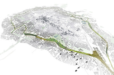
a bird's-eye view of it from the northeast, facing toward the southwest
a concept map of all transportation projects in Atlanta


Here are some of the things I learned from the tour:
- The idea for the Beltline (which was a graduate thesis project by Ryan Gravel at Georgia Tech in 1999) was spurred by his experience observing rail infrastructure in Paris, France...most likely referring to the Paris Tramway loops on the outer edge of the city)
map of current & proposed Paris Tramway lines
- The Atlanta Beltline is the largest urban redevelopment project in the United States
- There are 47 schools in total which are located within walking distance of the Atlanta Beltline corridor, 4 of which are high schools.
- The Historic Fourth Ward Park, which is already completed and opened, contains a storm water retention pond. (The area is one of the lowest in Atlanta, making it prone to major floods.)
Historic Fourth Ward Park retention pond
- The 33 miles of trail, 22 miles of light-rail transit, and 2000 acres of park space will connect 45 intown Atlanta neighborhoods.
DH Stanton Park is one of the many parks to be constructed
- The project focuses on "reusing" 4 historic railway lines which formed a small loop to detour downtown Atlanta in the days of freight shipping, most of which are abandoned and no longer used.
a section of the unused railway on the east side
- The redevelopment project of the Beltline addresses: population growth (Atlanta is the 2nd fastest growing metro area in the United States), traffic congestion, and unequal commercial investment in the southern and western sections of the city proper.
a neglected section of the formerly-Industrial Atlanta
- The Bellwood Quarry, which is on the Beltline trail, will become the largest park in Atlanta and the quarry will become a lake for recreational purposes as well as an emergency water supply for the city.
Bellwood Quarry
(read more about the water supply here: Westside Reservoir Park

I gave a presentation to the class this past week on transit-oriented development and green urbanism. Since it is on the same topic of the Beltline (since it is a Green TOD project itself) I thought that I would share the PowerPoint slides with anyone else not in the class. Enjoy:

The link in the slide showing Phoenix, Arizona's new light-rail system takes you to a really great video explaining all of the benefits of new transit projects like their's. Here is the link to the video:
http://www.treehugger.com/cars/video-phoenixs-brand-new-light-rail-has-60-more-users-than-expected.html

Thursday, February 16, 2012

Urban Air & Climate

Last week in class, Dr. Jeremy Diem came to our class to give a presentation on air pollution and its effect on climate change. He explained how particulate matter concentrations are attributed to higher temperatures which propagate already worsening urban air pollution levels, and it also creates changes in rainfall patterns. Here are some of the things we learned from a reading of his study:
1) There are 11 ozone monitoring stations in the Atlanta Metropolitan Statistical Area.
the locations of the monitoring stations
2) An HOD is a high-ozone-day and they are most common from June to August, the warmest season in Georgia. 
3) The southeastern part of Atlanta (McDonough, Conyers, Panthersville stations) generally observe the highest ozone levels, and the northerly-located stations of Yorkville and Dawsonville had the lowest levels.
4) HODs occur with hot, dry and calm weather.
5) HODs are associated with nitrogen oxide emissions from electric power plants.
6) HODs are perpetuated by above-average mixing heights above ground level (in the air) which causes it to spread over a larger area of the atmosphere above the Atlanta MSA.
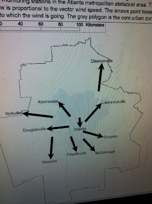
HODs and wind direction
7) Because air circulates clockwise around anticyclones (large descending parcels of air with high pressure), the diagram below shows that pollution from Power Plant B would blow pollution in a southern direction, and pollution would blow from Power Plant A in a northwestern direction. Thus, it makes sense that pollution levels are high to the southeast of Atlanta because of the large power plant to the northwest of the city.

Some of the other things we learned from the presentation, about...

- Particulates
    1) Small particulate concentrations in urban areas are caused by fossil fuel burning, mostly by automobiles.
    2) On-road emissions and power plants also attribute to particulates in the air.
    3) Places with high particulate optical depth include: the Sahara Desert due to dust, the Amazon rainforest from August to October due to biomass burning of forests, China and its coal-burning particulates, and the eastern half of the United States during the late summer months. (see photo below)
part of an animation showing change over time
- O-Zone
    1) The lowest levels during the day are recording in the early morning, around 7:00am.
    2) Towns to the south of Atlanta have the highest o-zone levels because they are downwind of Ohio River Valley winds.
    3) It is created by nitrous oxide emissions and volatile organic compounds, together with ultraviolet radiation, as shown in the photo below:
the "recipe" for o-zone
- Acid Rain
    1) It kills plant life, pollutes rivers and streams, and erodes stonework.
    2) Pure water has a pH of about 7, while acid rain is exponentially more acidic with a pH of about 4.
    3) There has been a shift in rainfall in the Atlanta area since the Clean Air Act of the mid-1970's due to small particulate matter clouds (NOx and SO2), with rainfall suppression before it and an increase after it. Observe the change below:
average rainfall in Atlanta

- CO2
    1) Fossil fuel emissions in the Atlanta MSA are approximately 4800 metric tons per square kilometer, which is 8 times more intense than the national average.
    2) Most concentrations of carbon dioxide in counties around the city of Atlanta are largely due to automobile emissions.
    3) There is a carbon dioxide monitoring station on the top of a GSU building which is constantly observing levels in the air in downtown Atlanta. You can see its results here:


Thursday, February 9, 2012

Sustainability and the Southface tour

Our class last week consisted of a tour of the Southface building, which is located near the Atlanta Civic Center. It was opened slightly over thirty years ago to promote green efficiency as well as quality construction for residential buildings. We learned that in the next forty years 2/3 of all growth in the United States will be in the South, therefore there is an urgent need for sustainable building in future construction projects. Here are some photos of the interesting things that have been used to build Southface:
windows facing south for maximum sunlight exposure
artificial stream for storm water runoff
paneled carpeting for easy replacement

window shields to distribute sunlight across rooms
automatic faucets with light-rechargeable batteries
display panel depicting up-to-date energy use
the machine room, which houses the compost toilet
minimal-water use toilets that feed into compost processor
green roof with German Sedums (stone-crop)
I think the most interesting thing about the Southface tour was that the aspects of sustainable energy found in the building were actually functioning! A common issue that people have with such technologies is that they do not work well, or work at all sometimes. This building is a wonderful example for people to observe quality construction and function in a manner that is easy to maintain, and is worth while. I highly recommend a visit if you are in the Atlanta area. It is located near the corner of Piedmont Avenue and Pine Street.
( http://www.southface.org/ )

Information about Sustainable Building 
from our text, Cities & Nature: (pg.238-240) 
1) The basic difference between the 20th century view of housing and the view of the sustainability perspective is that planners previously "tended to view housing within a vast infrastructure grid of gas, electrical power, water supply and sewerage." These grids became quite extensive with urban sprawl and suburban growth. More recently, sustainable housing planners "would localize the impacts of growth by insisting that as many resources as possible (water, energy and food) are source, processed and disposed of locally" (238).
2) In a house, the three main systems that contribute to sustainability are:
  - the waste system
    (example: a biolytic filter intakes sewage, good waste and other organic material into a multi-layered filter bed concrete tank with worms and micro-organisms. they sift, sort, digest and treat the solid waste and waste water from showers, baths, toilets, sinks, and dishwashers. it is then pumped into a UV-tank to further clean the water, which can then be used to water a garden.)
  - the drinking water system
    (example: rooftop rainwater collection tanks can collect and filter rain to be used for watering gardens and as drinking water)
  - the solar energy system \
    (example: photovoltaic cell solar panels)
3) Building materials are also an important part of sustainable building. The use of re-growth timber or materials produced by pollution-free manufacturing and free of toxic chemical discharges is necessary. (example: thick straw bales as wall insulation) Many use stoves which burn wood pellets or corn kernels instead of natural gas furnaces. Also, concrete flooring keeps a house cooler in summers and warmer in winters.
4) A very important concern for building sustainably is to maximize the use of the Sun during winter months to provide light and warmth by having the main windows of the house facing south, in the northern hemisphere.
5) Some suggestions for building materials in green buildings are as follows:
  - non-formaldehyde and/or non-toxic properties (improves indoor air quality)
  - high renewability or reusability (bamboo flooring, cork titles, etc.)
6) The advantages of green roofs include:
  - soaking up rain water instead of funneling runoff into sewers
  - reducing energy costs (summer AC needs, winter heating)
  - lowering carbon dioxide levels
  - providing bird habitats
  - removing nitrogen and other pollutants from rainfall
  - diminishing the 'Urban Heat Island' effect